![](/images/other/stat-length.png)
![Excursión A pie Nottertal-Heilinger Höhen - DE-Schlotheim - Issersheiligen - Photo](https://media.geolcdn.com/t/1900/400/ext.pjpeg?maxdim=2&url=https%3A%2F%2Fstatic1.geolcdn.com%2Fsiteimages%2Fupload%2Ffiles%2F1545311037marcheuse_200dpi.jpg)
DE-Schlotheim - Issersheiligen
SityTrail - itinéraires balisés pédestres
Tous les sentiers balisés d’Europe GUIDE+
![Longitud](/images/other/stat-length.png)
Longitud
3,6 km
![Altitud máxima](https://static1.geolcdn.com/siteimages/upload/files/1508320355ic_sort_altitude_max_24dp.png)
Altitud máxima
318 m
![Desnivel positivo](https://static1.geolcdn.com/siteimages/upload/files/1508320355ic_sort_den_pos_24dp.png)
Desnivel positivo
66 m
![Km-Effort](/images/other/stat-length.png)
Km-Effort
4,5 km
![Altitud mínima](https://static1.geolcdn.com/siteimages/upload/files/1508320355ic_sort_altitude_min_24dp.png)
Altitud mínima
276 m
![Desnivel negativo](https://static1.geolcdn.com/siteimages/upload/files/1508320355ic_sort_den_neg_24dp.png)
Desnivel negativo
66 m
![Boucle](https://static1.geolcdn.com/siteimages/upload/files/16400158638029165_repeat_loop_refresh_sync_direction_icon.png)
Boucle
No
Baliza
Fecha de creación :
2022-02-11 12:41:27.853
Última modificación :
2022-02-11 12:41:27.853
![A pie](https://static1.geolcdn.com/sitytour/trail-icons/100.png)
1h01
Dificultad : Fácil
![Escanee este código QR para abrir la excursión en la aplicación SityTrail](https://capi.geolives.com/qq0zvz2zws4bq2lad0pu/sitytour/trails/3087580/qr.png?size=200)
Aplicación GPS de excursión GRATIS
A propósito
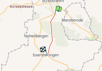
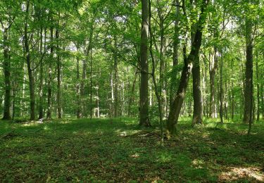
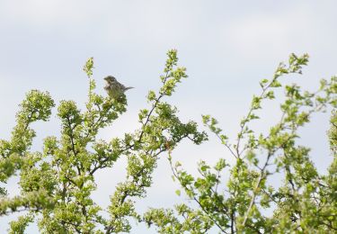
Ruta A pie de 3,6 km a descubrir en Turingia, Unstrut-Hainich-Kreis, Nottertal-Heilinger Höhen. Esta ruta ha sido propuesta por SityTrail - itinéraires balisés pédestres.
Descripción
Symbol: gelbes Quadrat
Localización
País:
Germany
Región :
Turingia
Departamento/provincia :
Unstrut-Hainich-Kreis
Municipio :
Nottertal-Heilinger Höhen
Localidad:
Unknown
Salida:(Dec)
Salida:(UTM)
615817 ; 5677333 (32U) N.
Comentarios
Excursiones cerca
![Excursión A pie Sondershausen - Grünes Quadrat - Photo](https://media.geolcdn.com/t/375/260/fb8420a5-9714-4eb9-92e4-0530ce65dedb.jpeg&format=jpg&maxdim=2)
![A pie A pie](https://static1.geolcdn.com/sitytour/trail-icons/100.png)
Grünes Quadrat
A pie
Fácil
Sondershausen,
Turingia,
Kyffhäuserkreis,
Germany
![](/images/other/stat-length.png)
6,4 km | 8,1 km-effort
1h 50min
![](https://static1.geolcdn.com/siteimages/upload/files/16400158638029165_repeat_loop_refresh_sync_direction_icon.png)
No
![Excursión A pie Greußen - Kirchengelscher Stadtweg - Photo](https://media.geolcdn.com/t/375/260/0cb1d7fe-0da1-4c4a-939e-105f921437f1.jpeg&format=jpg&maxdim=2)
![A pie A pie](https://static1.geolcdn.com/sitytour/trail-icons/100.png)
Kirchengelscher Stadtweg
A pie
Fácil
Greußen,
Turingia,
Kyffhäuserkreis,
Germany
![](/images/other/stat-length.png)
10,5 km | 12,9 km-effort
2h 55min
![](https://static1.geolcdn.com/siteimages/upload/files/16400158638029165_repeat_loop_refresh_sync_direction_icon.png)
No
![Excursión A pie Sondershausen - Brunnen-Wanderweg - Photo](https://media.geolcdn.com/t/375/260/1ec9e143-38fc-4858-bcfe-53fcffef013e.jpeg&format=jpg&maxdim=2)
![A pie A pie](https://static1.geolcdn.com/sitytour/trail-icons/100.png)
Brunnen-Wanderweg
A pie
Fácil
Sondershausen,
Turingia,
Kyffhäuserkreis,
Germany
![](/images/other/stat-length.png)
6,5 km | 9,3 km-effort
2h 6min
![](https://static1.geolcdn.com/siteimages/upload/files/16400158638029165_repeat_loop_refresh_sync_direction_icon.png)
Sí
![Excursión A pie Sondershausen - Frauenbergrundweg - Photo](https://media.geolcdn.com/t/375/260/ab9354d1-a27b-4c7e-934f-ca082b13fe59.jpeg&format=jpg&maxdim=2)
![A pie A pie](https://static1.geolcdn.com/sitytour/trail-icons/100.png)
Frauenbergrundweg
A pie
Fácil
Sondershausen,
Turingia,
Kyffhäuserkreis,
Germany
![](/images/other/stat-length.png)
11 km | 14,7 km-effort
3h 20min
![](https://static1.geolcdn.com/siteimages/upload/files/16400158638029165_repeat_loop_refresh_sync_direction_icon.png)
Sí
![Excursión A pie Hörselberg-Hainich - Steinbergweg - Photo](https://media.geolcdn.com/t/375/260/9328697d-d80e-4efd-9b27-12794edb1b59.jpeg&format=jpg&maxdim=2)
![A pie A pie](https://static1.geolcdn.com/sitytour/trail-icons/100.png)
Steinbergweg
A pie
Fácil
Hörselberg-Hainich,
Turingia,
Wartburgkreis,
Germany
![](/images/other/stat-length.png)
9,9 km | 11,7 km-effort
2h 39min
![](https://static1.geolcdn.com/siteimages/upload/files/16400158638029165_repeat_loop_refresh_sync_direction_icon.png)
Sí
![Excursión A pie Hörselberg-Hainich - Craulaer Kreuz - Photo](https://media.geolcdn.com/t/375/260/d527f938-3761-40a7-959b-f2334af5c53f.jpeg&format=jpg&maxdim=2)
![A pie A pie](https://static1.geolcdn.com/sitytour/trail-icons/100.png)
Craulaer Kreuz
A pie
Fácil
Hörselberg-Hainich,
Turingia,
Wartburgkreis,
Germany
![](/images/other/stat-length.png)
5,7 km | 7 km-effort
1h 34min
![](https://static1.geolcdn.com/siteimages/upload/files/16400158638029165_repeat_loop_refresh_sync_direction_icon.png)
No
![Excursión A pie Nottertal-Heilinger Höhen - Rundweg Volkenrodaer Wald - Photo](https://media.geolcdn.com/t/375/260/2bee7781-1d55-4ca3-abe1-e4f21aa1ed71.jpeg&format=jpg&maxdim=2)
![A pie A pie](https://static1.geolcdn.com/sitytour/trail-icons/100.png)
Rundweg Volkenrodaer Wald
A pie
Fácil
Nottertal-Heilinger Höhen,
Turingia,
Unstrut-Hainich-Kreis,
Germany
![](/images/other/stat-length.png)
3,9 km | 4,6 km-effort
1h 2min
![](https://static1.geolcdn.com/siteimages/upload/files/16400158638029165_repeat_loop_refresh_sync_direction_icon.png)
No
![Excursión A pie Unstrut-Hainich - Saugrabenweg - Photo](https://media.geolcdn.com/t/375/260/be7f7704-91d7-43d9-8d9a-8d6d8cf45b69.jpeg&format=jpg&maxdim=2)
![A pie A pie](https://static1.geolcdn.com/sitytour/trail-icons/100.png)
Saugrabenweg
A pie
Fácil
Unstrut-Hainich,
Turingia,
Unstrut-Hainich-Kreis,
Germany
![](/images/other/stat-length.png)
4,1 km | 5,7 km-effort
1h 17min
![](https://static1.geolcdn.com/siteimages/upload/files/16400158638029165_repeat_loop_refresh_sync_direction_icon.png)
No
![Excursión A pie Sondershausen - J.-K. Wezel-Weg - Photo](https://media.geolcdn.com/t/375/260/97c9a10f-9c44-46c9-9390-60bbd6916f7a.jpeg&format=jpg&maxdim=2)
![A pie A pie](https://static1.geolcdn.com/sitytour/trail-icons/100.png)
J.-K. Wezel-Weg
A pie
Fácil
Sondershausen,
Turingia,
Kyffhäuserkreis,
Germany
![](/images/other/stat-length.png)
7,4 km | 9,6 km-effort
2h 10min
![](https://static1.geolcdn.com/siteimages/upload/files/16400158638029165_repeat_loop_refresh_sync_direction_icon.png)
No